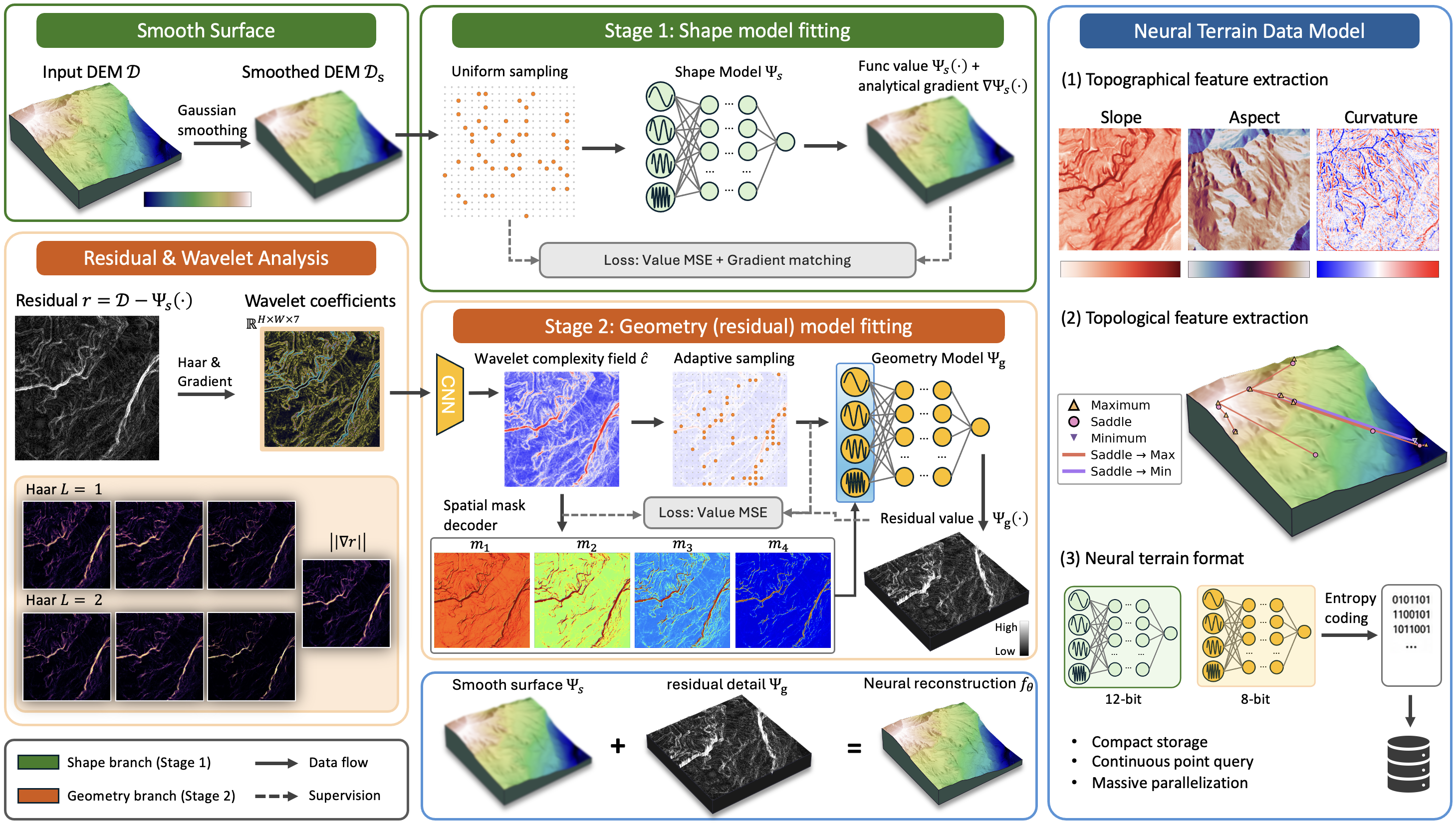
Earlier work: ImplicitTerrain
Digital elevation models (DEMs) underpin terrain analysis in Geographic Information Systems (GIS), but commonly as raster representation, they rely on interpolation for off-grid sampling and finite-difference operators for derivative-based analysis. Implicit neural representations (INRs) offer a continuous alternative, but prior terrain INRs lack explicit frequency control, neglect the gradient structure of terrain, and remain too large and costly to train for practical deployment. We present ImplicitTerrainV2, which advances terrain INRs toward a compact, efficient neural terrain data format by combining a spectral control mechanism with wavelet-guided spatial adaptivity, derivative-aware supervision, and post-training model compression. At its core, a wavelet complexity field (WCF) derives spatially-adaptive frequency masks from analytically computed wavelet coefficients, localizing high-frequency capacity to complex terrain regions. The same field guides complexity-aware adaptive sampling that concentrates training in high-complexity regions, while gradient matching applies extra supervision to enforce the smooth manifold structure of terrain DEMs for improved derivative fidelity. Post-training mixed-precision quantization and entropy coding reduce storage to 1.23 bpp with a 0.28 dB PSNR drop. On 50 morphologically diverse Swiss terrain tiles, ImplicitTerrainV2 reaches 66.25 dB end-to-end PSNR, improving over the prior work by 5.70 dB while using 3.2× fewer parameters and training in 55 s per tile on a single GPU. Our compressed neural format is competitive with several established DEM codecs in rate-distortion performance, while additionally supporting off-grid point queries, closed-form derivative evaluation, and resolution-independent reconstruction, which may benefit many downstream GIS applications.
The representation is a cascade of two frequency-controlled SIREN networks. A shape model Ψs fits a Gaussian-smoothed version of the DEM and captures the large-scale smooth manifold, while a geometry model Ψg fits the full-resolution residual and recovers fine-scale detail; the reconstruction is their sum. Each stage freezes its first layer at initialization so that it acts as a designed Fourier basis, following TUNER. A SIREN's representable spectrum is set by the rows of that layer, so freezing it gives explicit control over the frequencies the network can express. The SIREN backbone is retained because any derivative of a sinusoid remains a sinusoid, so the network yields smooth and analytically tractable derivatives at all orders, a property important for the topographical and topological analysis we target. Both stages use three hidden layers of width 128.
The frozen first-layer frequencies of the geometry model are partitioned into bands by magnitude, and the higher bands are gated per spatial location by masks in [0, 1]. This band-wise masking structure is adopted from SASNet; our departure lies in how the masks are produced. SASNet trains a hash-grid branch jointly with the SIREN under the residual reconstruction loss. Since that residual is itself the geometry model's fitting target, the masks must be inferred from the same smooth, low-contrast signal they are meant to gate, which causes them to degrade on post-shape residuals. We instead compute a stationary wavelet transform of the residual at two levels with Haar wavelets, append the local gradient magnitude as a seventh channel, and decode the stack with a small CNN (7 → 48 → 48 → 1) into a single scalar complexity field. All masks are sliced from that one field by ordered learned thresholds, which ensures containment by construction: the active region of each higher-frequency band sits inside those of the lower bands, the hierarchy reported by SASNet. The WCF decoder uses 24K parameters, against 39K for SASNet's masking module.
Supervising derivatives alongside values, known as Sobolev training, is uncommon in neural field training because many signals lack well-defined or easily computable ground-truth gradients. Terrain DEMs are a notable exception: the partial derivatives of the elevation function correspond directly to physical slope components, are computable from the DEM by finite differences, and are essential for downstream geospatial analysis. Gradient matching adds a Hermite-style derivative term to the elevation loss on the shape model. Measured in isolation, gradient matching reduces gradient MAE by 6.4× and worst-case elevation error by 7.7× against the SIREN baseline. Combined with the frequency embedding, it gives the best shape-stage result on every metric (70.54 dB PSNR, 0.015 gradient MAE, 1.37 m maximum absolute error).
In the geometry stage, whose target has strongly non-uniform spatial importance, the normalized complexity field is used directly as an importance map for coordinate sampling. This replaces the multi-scale progressive training of the prior work. The shape stage instead uses uniform random subsampling of its band-limited target. For storage, a per-layer sensitivity sweep shows that the two cascade stages tolerate different bit widths: the shape model needs 12 bits to preserve the gradient accuracy that downstream analysis depends on, while the geometry model and the WCF decoder tolerate 8 bits with negligible PSNR loss. We therefore quantize at 12b+8b and entropy-code the result. The frozen frequency-embedding layer is reproducible from its initialization seed and is not stored at all.
| Method | Params | E2E PSNR (dB) ↑ | MAE (m) ↓ | MaxAE (m) ↓ | Peak Mem (GB) ↓ | Geo-Iter (ms) ↓ |
|---|---|---|---|---|---|---|
| ImplicitTerrain | 397K | 60.55 ± 5.67 | 0.197 | 29.73 | 9.8 | 81.9 |
| ImplicitTerrain-128 | 100K | 49.74 ± 5.34 | 1.436 | 32.46 | 4.9 | 34.5 |
| SASNet | 139K | 64.48 ± 4.27 | 0.125 | 17.56 | 5.4 | 41.3 |
| ImplicitTerrainV2 | 124K | 66.25 ± 4.09 | 0.132 | 11.85 | 1.7 | 20.2 |
Fitting results on all 50 tiles, best per column in bold. E2E PSNR (mean ± std) is computed on the full cascaded reconstruction. MAE and MaxAE are scaled back to the original elevation scale. Peak Mem is the peak GPU memory during training, and Geo-Iter is the per-iteration wall-clock time of the geometry model, which is the training bottleneck.
The evaluation set is 50 tiles drawn from swisstopo's
swissALTI3D product, selected from 33,399 candidates
by farthest-point sampling in a 10-dimensional morphology and
frequency descriptor space to maximize morphological diversity.
Each tile covers 1000 × 1000 pixels at 1 m
resolution, and the set spans alpine ridges, glacial valleys,
plateaus, and mixed terrain with elevation ranges from 101 m
to 1,668 m.
ImplicitTerrainV2 reaches 66.25 dB end-to-end PSNR, improving over ImplicitTerrain by +5.70 dB at 3.2× fewer parameters and 5.8× lower peak GPU memory. Against SASNet it gains +1.77 dB and reduces worst-case error by 33% (11.85 versus 17.56 m) while running 2.0× faster per iteration. SASNet attains a slightly lower MAE (0.125 versus 0.132 m), likely a consequence of its larger auxiliary masking module, which can fit localized outliers more aggressively; we prioritize PSNR and MaxAE as the primary metrics since they better reflect worst-case fidelity for downstream analysis.
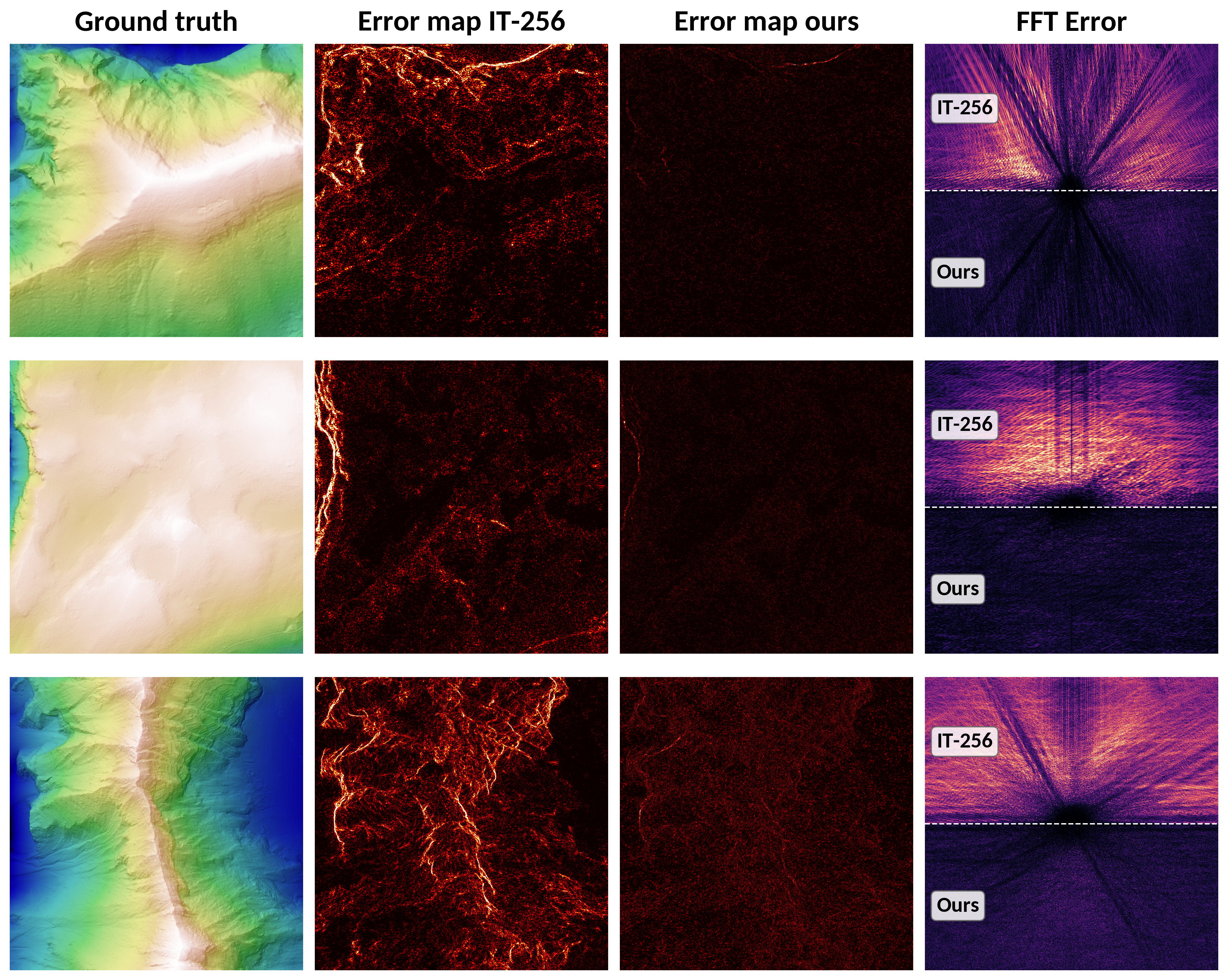
Qualitative comparison on three terrain tiles. The 2nd and 3rd columns show spatial error maps for ImplicitTerrain and ImplicitTerrainV2 (hot colormap for the absolute error up to 1.25% of the input elevation), while the 4th column shows the frequency-domain error map comparison.
ImplicitTerrainV2 concentrates residual errors on complex features, leaving flat and smooth regions with minimal error, which illustrates the effect of WCF-guided frequency allocation. The frequency-domain error maps in the last column show systematic directional streaks for ImplicitTerrain, indicating missing or poorly fitted frequency components. These artifacts are alleviated in ImplicitTerrainV2's reconstruction, supporting the interpretation that the frequency embedding and WCF masks achieve broader and more accurate spectral coverage.
| Format | bpp | PSNR (dB) ↑ | MAE (m) ↓ |
|---|---|---|---|
| GeoTIFF+DEFLATE | 15.29 | lossless | 0 |
| FPZIP | 11.78 | lossless | 0 |
| LERC+ZSTD (z=0.1) | 6.06 | 74.35 | 0.045 |
| ZFP (rate=4) | 4.00 | 68.19 | 0.057 |
| Quantize+ZSTD (10b) | 2.86 | 71.08 | 0.092 |
| SZ3 (ε=0.05 m) | 1.96 | 80.45 | 0.023 |
| Ours (float32) | 4.03 | 66.25 | 0.133 |
| Ours (float16) | 1.77 | 66.25 | 0.133 |
| Ours (12b+8b) | 1.23 | 65.97 | 0.137 |
| Ours (int8) | 1.04 | 61.30 | 0.239 |
Storage efficiency comparison, averaged over the 50 tiles. Classical formats require a full decompression step before any query; the neural format supports queries at arbitrary coordinates with analytical gradient computation, with no decompression required.
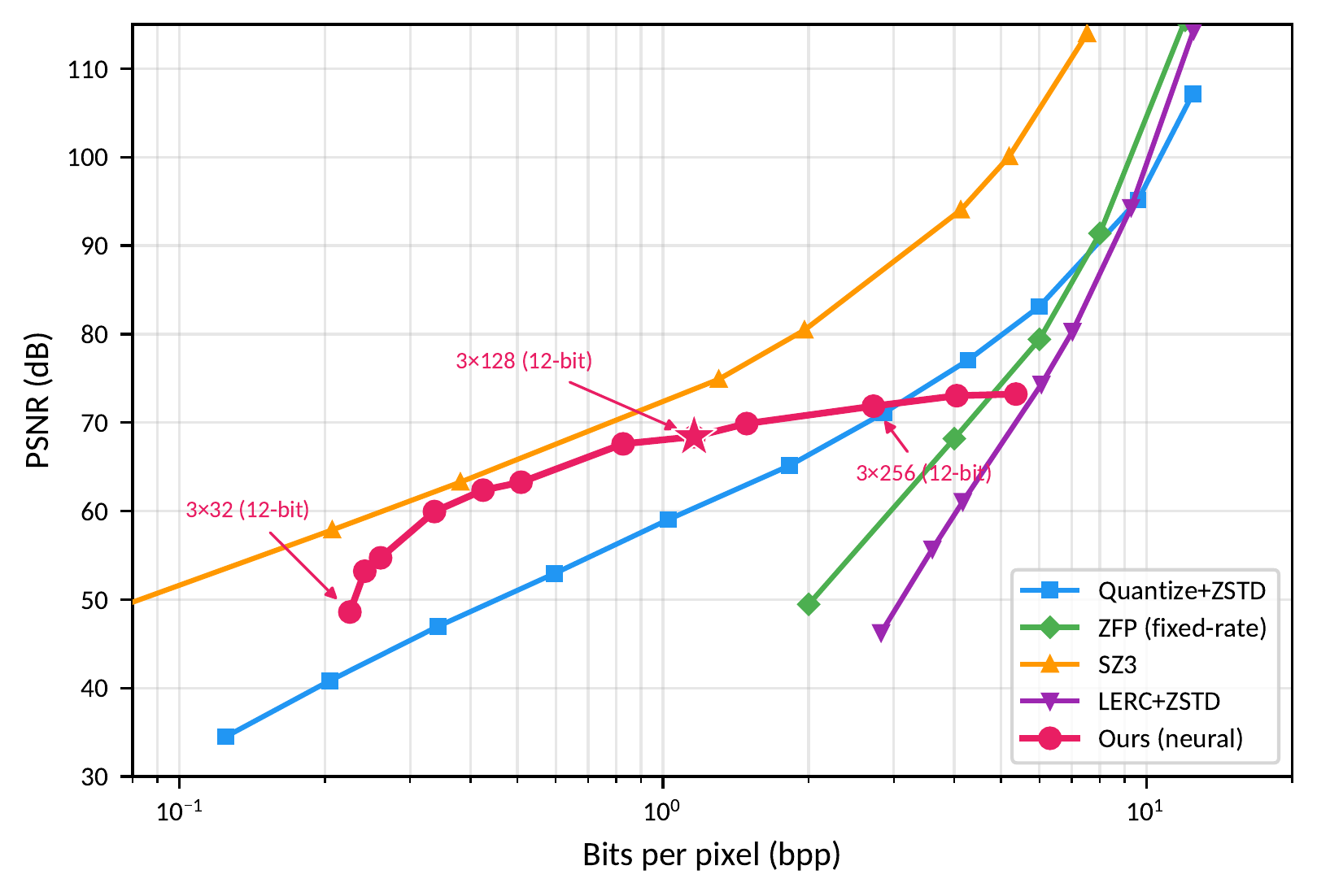
Rate-distortion comparison across bitrates. Red points trace the neural format as network width and depth vary under mixed-precision quantization and entropy coding, while traditional codecs are swept over their quality parameters. The star marks the configuration used throughout the other experiments.
At the 12b+8b operating point the stored model occupies 1.23 bpp with a 0.28 dB degradation from the uncompressed model, a 3.2× compression ratio from float32. Across the practical bitrate range of 0.5 to 2 bpp, the neural format outperforms Quantize+ZSTD, ZFP, and LERC+ZSTD; SZ3, an error-bounded compressor particularly suited to smooth scientific data, remains stronger at matched rates. The neural format also incurs a one-time encoding cost that traditional codecs do not require, and that cost is amortized when the encoded model is queried repeatedly for analysis. In exchange, the neural format provides capabilities absent from the classical ones: continuous elevation queries at arbitrary coordinates, analytical gradients, and resolution-independent topological analysis. These would otherwise require separate pipelines over decompressed grid data.
The compiled model evaluates 77.3 M coordinate queries per second on an RTX A5000, returning both elevation and gradient in a single pass. This represents a 4.63× speedup over naïve autograd-based gradient computation and is 2.24× faster than naïve elevation-only queries without compilation, indicating that the compiled analytical gradient path adds a small overhead to elevation queries.
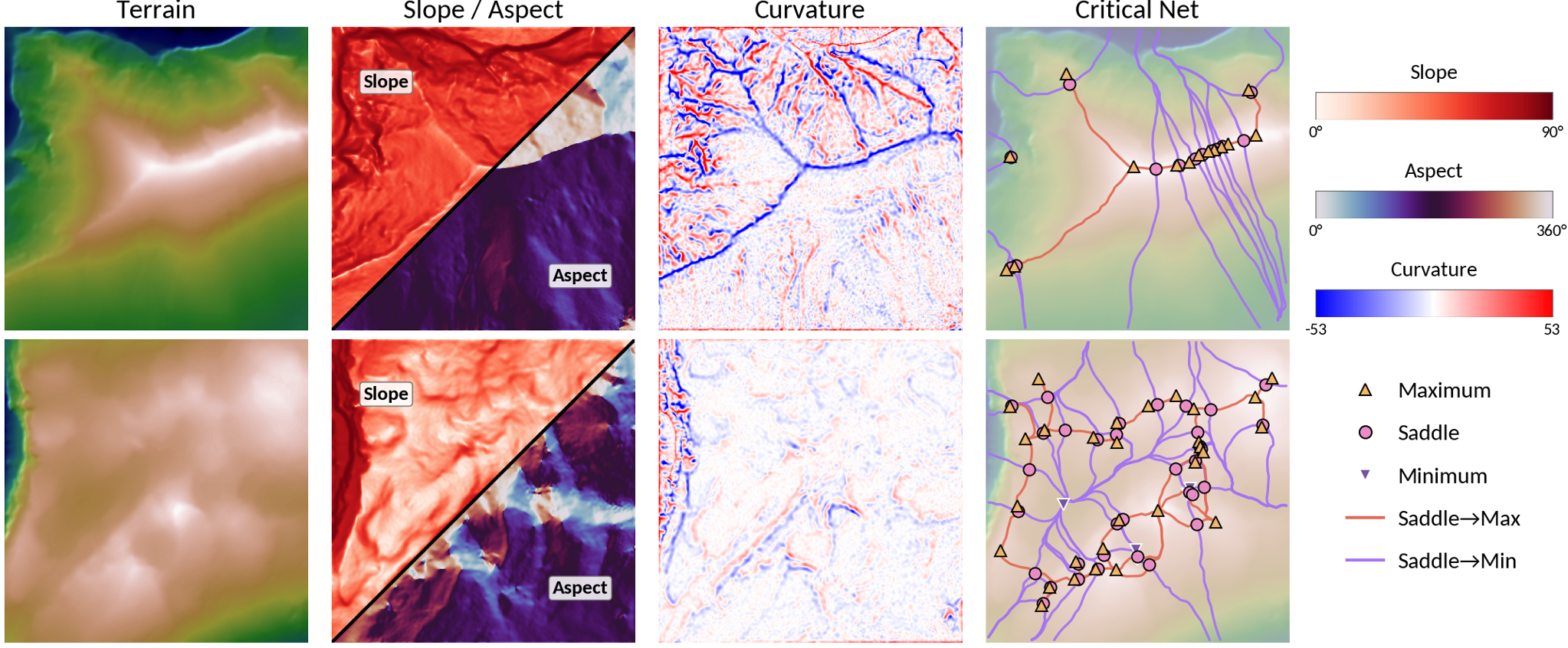
Topographic features and topological skeleton derived from the shape model Ψs via analytical gradients on two representative tiles. From left to right: elevation (DEM hillshade), combined slope and aspect (split along the anti-diagonal), mean curvature, and the critical network. Critical points are located where the gradient vanishes and classified via the Hessian eigenvalues. Separatrix lines traced by gradient delineate ridges and valleys.
Following ImplicitTerrain, we demonstrate two applications: topographic feature computation and topological analysis. Both operate on the shape model, which captures the smooth manifold structure of the terrain. Topological analysis in particular requires a smooth, noise-free surface with accurate gradients, which the shape model provides by design. Slope and aspect follow from the first-order gradient, and mean curvature from the second-order derivatives via the standard differential-geometry formula. None of these quantities requires grid discretization; all can be evaluated at arbitrary resolution, which removes the resolution dependence of finite-difference operators. For the topological skeleton, critical points are found by Newton-Raphson iteration on the gradient and classified by the sign pattern of the Hessian eigenvalues, and four separatrices are integrated from each saddle to produce the Morse-Smale complex that delineates ridges, valleys, and drainage divides. This is the same Morse-theoretic analysis demonstrated by ImplicitTerrain, now running on a more accurate continuous field. These applications are demonstrated qualitatively; the quantitative evidence for derivative-based analysis in this work is the gradient fidelity of the shape model.
@inproceedings{feng2026implicitterrainv2,
  title     = {ImplicitTerrainV2: Wavelet-Guided Spatially Adaptive Neural Terrain Representation},
  author    = {Feng, Haoan and Xu, Xin and De Floriani, Leila},
  booktitle = {Proceedings of the 34th ACM International Conference on Advances in Geographic Information Systems (SIGSPATIAL '26)},
  year      = {2026},
  eprint    = {2605.22556},
  archivePrefix = {arXiv},
  primaryClass  = {cs.LG}
}