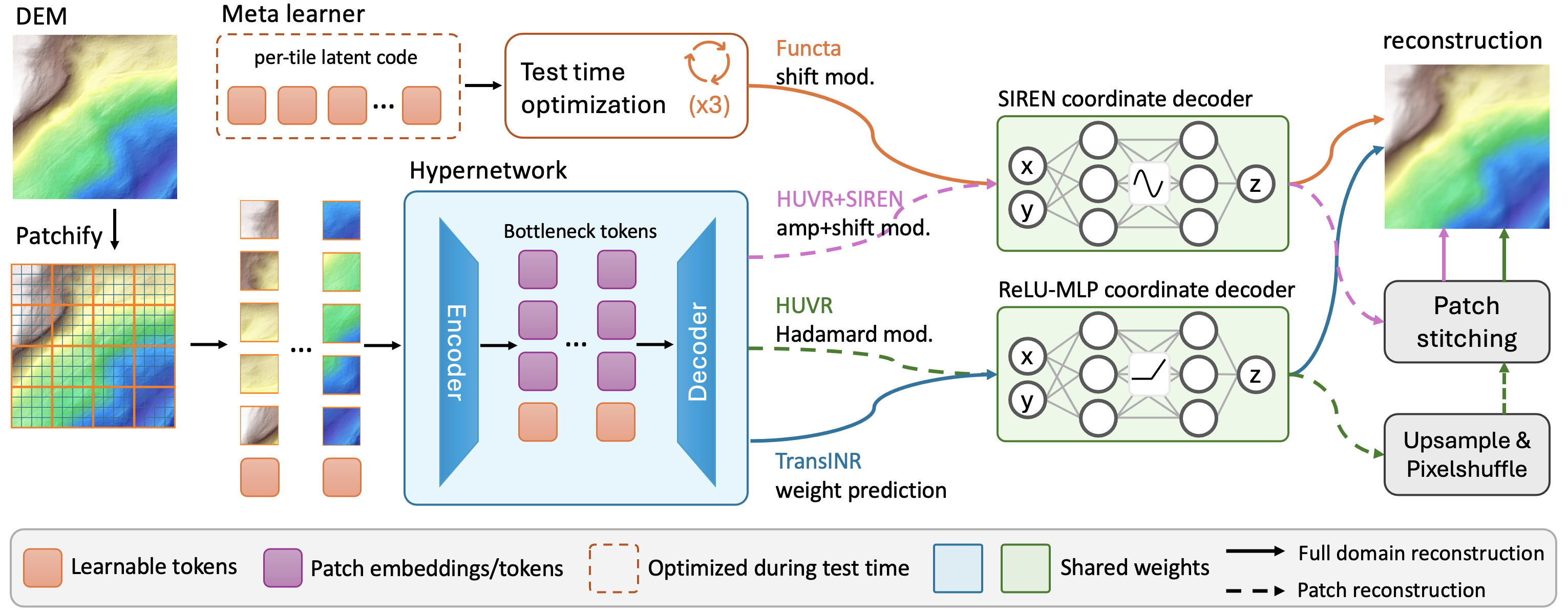
Implicit neural representations (INRs) model a terrain tile as a continuous coordinate-to-elevation function, supporting analytic derivatives and arbitrary-resolution decoding, but fitting a separate network for every tile does not scale to large elevation datasets. Amortized neural representations reduce this cost with a shared model: each tile is mapped to a compact per-tile payload, and a shared coordinate decoder reconstructs the heightfield from it. These methods were developed primarily for natural images, and their suitability for terrain heightfields remains unclear. We introduce a controlled benchmark on a 1 m/pixel terrain dataset and evaluate three representative methods under a unified protocol. Observing a clear cross-domain gap, we propose HUVR+SIREN, a bounded adaptation of the strongest benchmarked method that replaces its coordinate decoder with a smooth, analytically differentiable one. It attains the best height and derivative fidelity on the benchmark (+2.83 dB over the strongest baseline) at the same per-tile payload as HUVR, and tolerates int8 post-training quantization of that payload with a 0.15 dB loss. Diagnostics further show that the per-tile bottleneck is already near its useful limit, localizing the remaining amortization gap in the shared post-bottleneck pipeline.
An INR encodes elevation as a coordinate network mapping each spatial coordinate to the corresponding height. Per-instance fitting optimizes a separate network for every tile, which does not scale: fitting one tile to high fidelity takes minutes of per-tile optimization on a GPU. Amortized methods share a pipeline across the dataset instead. Each tile is mapped (typically, but not always, by a hypernetwork) to a per-tile bottleneck token, and a shared coordinate decoder is queried at each coordinate conditioned on that token. The token is the only per-tile object stored, so its dimensionality sets the per-tile storage budget. Per-instance fitting generally reaches higher per-tile quality than amortized inference, and we call the difference the amortization gap.
The three benchmarked methods instantiate this differently. TransINR predicts the full weights of a ReLU MLP in one forward pass. Functa has no hypernetwork: a 512-dimensional global modulation vector conditions a shared SIREN, and is recovered at inference by a short meta-learned inner loop. HUVR factors the hypernetwork around a low-dimensional patch-token bottleneck (256 patches at width 32, plus one global token, giving a per-tile token of 8,224 floats); its transformer decoder turns that token into per-patch modulations of a shared 3-layer ReLU MLP, whose per-patch outputs are stitched and refined by a Conv+PixelShuffle upsampler.
We treat a terrain heightfield as a smooth surface, whose downstream interpretation relies on continuous gradients and Laplacians. HUVR's ReLU coordinate decoder is piecewise-linear, with derivatives that are discontinuous at activation breakpoints, a poor match for such a surface. We therefore replace it with a SIREN, whose sinusoidal activations are infinitely differentiable, and condition it on the patch token through ModulatedSIREN's per-layer amplitude modulation, which we extend with an additive phase shift inside the sinusoid. The decoder is a 4-layer SIREN of width 256 with ω0 = 10, evaluated directly at each pixel coordinate, which removes HUVR's convolutional upsampler. The restricted modification is deliberate: by holding the encoder, hypernetwork decoder, bottleneck structure, and training protocol fixed, the comparison isolates how the coordinate-decoder design transfers from natural images to terrain.
We benchmark on a bare-earth digital terrain model of Switzerland
derived from swisstopo's swissALTI3D product at
1 m/pixel, partitioned into 256×256 tiles with per-tile
normalization: 3,338 training, 420 validation, and 432 test tiles.
Splits are assigned at the source-region level so no two tiles in
different splits overlap spatially, and all reported numbers are
computed on the held-out test split. Each reproduction starts from
the published implementation with a single input-layer edit from
three-channel images to the single-channel heightfield, and trains
under its own published schedule until the validation loss plateaus.
| Method | PSNR ↑ | RMSEz ↓ | ∇f ↓ | ∇²f ↓ | #floats |
|---|---|---|---|---|---|
| TransINR | 41.56 | 0.222 | 0.095 | 0.103 | 197,376 |
| Functa | 35.00 | 0.498 | 0.115 | 0.095 | 512 |
| HUVR | 48.86 | 0.092 | 0.068 | 0.091 | 8,224 |
| HUVR+SIREN | 51.69 | 0.066 | 0.053 | 0.076 | 8,224 |
Test split (n = 432). PSNR in dB, RMSEz in meters; ∇f (m/px) and ∇²f (m/px²) are gradient and Laplacian RMSE against finite-difference references. #floats is the per-tile payload; shared model weights are amortized across the dataset and excluded.
Among the three reproduced methods, HUVR achieves the highest height fidelity, the lowest derivative errors, and a per-tile representation an order of magnitude smaller than TransINR's. In this system-level comparison, the patch-token HUVR pipeline transfers most effectively to terrain, outperforming the reproduced TransINR and Functa configurations by 7.3 and 13.9 dB. HUVR+SIREN improves all reported fidelity metrics at unchanged per-tile storage: a +2.83 dB gain and a 28% height-error reduction at the same 8,224-float payload, with gradient RMSE reduced by 23% and Laplacian RMSE by 17%.
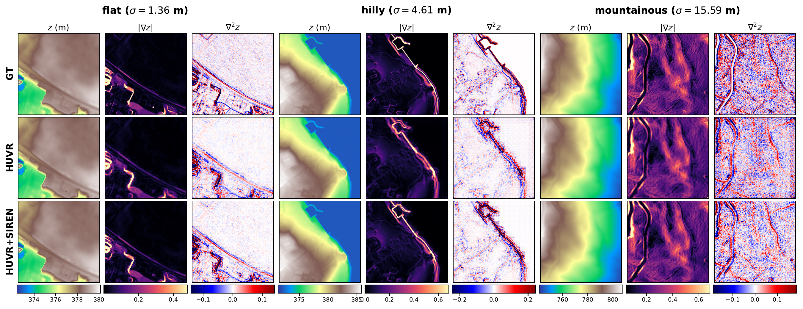
Reconstruction of three tiles at the 10%, 50%, and 90% quantiles of per-tile elevation standard deviation (flat, hilly, mountainous). Columns within each group show elevation, gradient magnitude, and Laplacian; rows are ground truth, HUVR, and HUVR+SIREN.
Downstream geospatial analyses, from slope and curvature estimation to hydrological modeling, interpret the surface through its derivatives rather than through elevation values alone. Derivative fidelity is measured against central finite-difference references from the ground-truth tile, computed analytically by automatic differentiation for the SIREN-based decoders and by finite differences of the decoded heightfield for the ReLU-based decoders. HUVR+SIREN reconstructs the gradient and Laplacian fields more faithfully than HUVR, as the figure above illustrates. The improvement also holds for the worst-case tiles, whose maximum gradient and Laplacian errors drop by 20% and 19%.
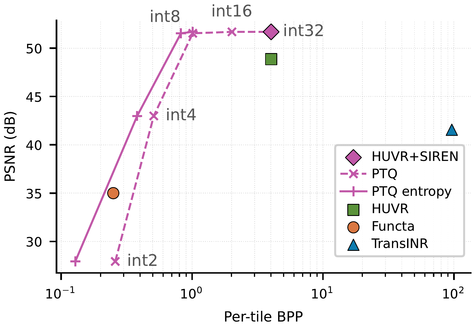
Rate–distortion frontier on the test split under post-training quantization (PTQ) of the bottleneck token. The solid curve is an estimated Shannon lower bound from per-dimension entropy models; the dashed curve is fixed-width.
The per-tile payload tolerates aggressive post-training quantization. Quantizing the bottleneck token to int8 with symmetric per-dimension min–max scales costs only 0.15 dB (51.54 dB at 1.012 BPP fixed-width), so the int8 configuration still reconstructs more faithfully than HUVR at full precision while storing a quarter of the bits. Below int8, reconstruction quality degrades sharply. Removing the upsampler also cuts analytical decoder FLOPs per pixel by 19%, though measured wall-clock per tile is slightly higher than HUVR's (18.11 vs. 15.96 ms) because independent per-pixel SIREN evaluation is less hardware-efficient than HUVR's fused upsampler.
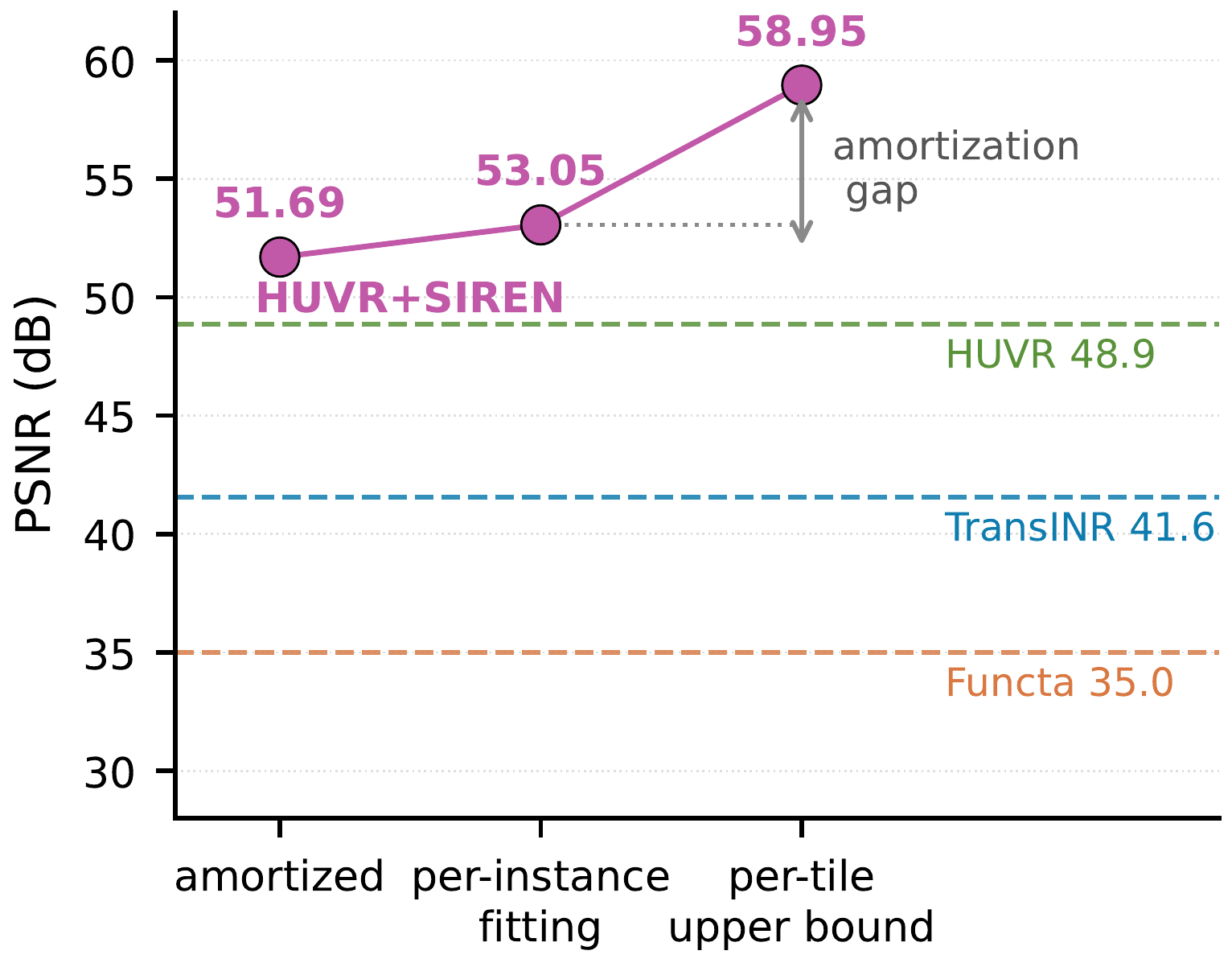
Decomposing the amortization gap of HUVR+SIREN. PSNR as per-tile flexibility expands: amortized encoding, the per-instance fitting bound, and the per-tile full-model upper bound. Dashed lines mark the amortized cross-method benchmark.
Two diagnostics locate the amortization gap. The per-instance fitting bound freezes the shared model and continues optimizing only the bottleneck token per tile from its amortized value; it reaches 53.05 dB, only +1.36 dB over amortized inference, so the encoder already produces tokens close to the best 32-dimensional token the shared decoder can use. The per-tile full-model upper bound additionally lets the hypernetwork decoder and SIREN base weights specialize per tile (destroying amortization, so it is a structural ceiling rather than an inference recipe); it reaches 58.95 dB, more than 7 dB above the amortized 51.69 dB. A PCA of all patch tokens is consistent with this observation: five of the 32 dimensions carry 95% of the variance. Within the tested dataset scale and configuration, the amortization gap thus resides in the shared post-bottleneck pipeline rather than in the per-tile token, and narrowing it requires a more expressive shared pipeline rather than a wider token.
One-at-a-time ablations against the HUVR+SIREN baseline cover patch size, bottleneck width, SIREN base frequency, modulation interface, and training-set size. Patch granularity has the largest remaining effect on the quality-storage tradeoff: halving the patch size gains +4.90 dB, at 4× the payload. Widening the bottleneck gives rapidly diminishing returns, with the unprojected D = 768 setting recovering only +2.22 dB, so the per-tile token is already near its useful limit. The full ablation table is in the paper.
The findings characterize a single geographic source at a single ground sampling distance, and a direct rate–distortion comparison against production DEM codecs such as LERC and ZFP remains open. These results motivate extending the benchmark to additional geographic regions, sampling distances, and codec baselines, and redesigning the shared post-bottleneck pipeline to recover more of the per-tile fitting ceiling.
@inproceedings{feng2026rethinking,
  title     = {Rethinking Amortized Neural Representations for High-Resolution Terrain Elevation Data},
  author    = {Feng, Haoan and Xu, Xin and De Floriani, Leila},
  booktitle = {Proceedings of the 34th ACM International Conference on Advances in Geographic Information Systems (SIGSPATIAL '26)},
  year      = {2026},
  eprint    = {2606.00404},
  archivePrefix = {arXiv},
  primaryClass  = {cs.CV}
}